``

Monday, 1 June 2015

Westpoint Lake 1 June 2015

Yesterday evening saw some strange lighting but they say a red sky at night is a Sheppard’s delight so maybe that is true even if
 it is raining, because this morning we woke to bright sunshine, shame it didn’t last.

As the weather was nice we walked up to Mow Cop Castle, if you plan on doing this be warned there is a 1 in 4 hill to climb, there is also a pub near the castle called The Cheshire View, it doesn’t open lunch times during the week. The castle is another National Trust property but there is not a single sign directing you to it. What we did find when we reached it that people have thrown rubbish inside it and even dog poo bags.
As you can see it was already clouding over and the wind had a chill to it. Walking the 1½ miles back is a bit easier because its down hill. We were back on the boat about 11 am and set off as  soon as the two approaching boats had passed. Between Scholars Green where we moored and Lock 13 there is a wooden pedestrian swing bridge. This has a chain attached to it so pedestrians can pull it across when the want to use it, I am not sue how the swing it open again if they are coming the other way.
You can just see the chain hanging off the end and down into the water where it is attached to the tow path side.

As the boat we were following pulled in for water Lock 13, Hall Green lock was ready for us. Since we were this way last I have done a bit of research and also had a couple of people contact me. This is the official end of The Macclesfield canal and it is where it joins the Trent and Mersey canal. This use to be the site of two stop locks with two lock keepers who lived in two cottages. One was employed by the Macclesfield Canal company the other The Trent and Mersey and each looked after their own lock. When the Macclesfield canal was dug the water level to Bosley locks was the same as the summit of the Trent and Mersey, but if the Macclesfield canal lost water it would flow from the Trent and Mersey, very unlikely as its the lowest point on the Macclesfield canal, but just in case the Trent and Mersey company built a stop lock, a more likely situation would be a drop in level on the Trent and Mersey summit would draw water from the Macclesfield so the built a second lock but facing the other way. The two locks were about  5 mts apart and the gate recesses of the Trent and Mersey locks are still visible below the present lock.
 Now the level of the Trent and Mersey is about 50 cm lower than the Macclesfield as they had to lower the summit to give more headroom in the Harecastle tunnel to compensate for it subsiding, so now there is no possibility of water flowing into the Macclesfield Canal.


Even though the next one and a third miles of canal to Hardings Wood Junction are officially the Trent and Mersey canal it is commonly know as the Macclesfield canal and on bridge 98 at Hardings wood Junction is this plaque.
Here we turned right, a much easier turn than when we came up, as the canal is wider south of the junction and we are back on the brown water.
It was only a short run now to the north portal of Harecastle where there were already 2 boats waiting. The tunnel keep informed us that we would have a ¾ hour wait as there were 6 boats coming through, we were also joined by two more bats going south. The Tunnel keeper came round and gave us a briefing under bridge 131 as it had now started raining. We had plenty of time to eat lunch before it was our turn to enter the tunnel. It nice to see that the skeleton is still in there keeping an
 eye on things, hiding in the second recess. It was quite murky in the tunnel and we slowly caught up with the boat ahead as it was hard to judge how far in front he was. Once clear of the tunnel we pulled over to fill with water and continued our wet journey as far as Westport Lakes where we stopped on the 48hr visitor moorings for the night. We are moored just south of a sunken cruiser as there were no spaces long enough before that, there were a few that would suit 40 ft boats but people tend to spread out a bit wasting valuable visitor mooring space.

Today’s Journey
30 5¾ miles 1 lock, 1 junction, 2 canals in 3½ hours but it does include a ¾ hour wait at the tunnel.

Sunday, 31 May 2015

Scholars Green Sunday 31 May 2015

Well we went to sleep with the sound of the rain, we woke up to the sound of the rain, we ate breakfast to the sound of the rain and we wet off in the rain. I must have rained for 11 hours I would think dropping over 8 mm on us.

The other day I posted a picture of a communication tower on top or a hill,(top left) this is what we could see this morning.
 After Potters farm bridge and before the aqueduct we passed this arm, I have looked on the 1905 map but cant find out what it was so I guess it was a wharf for someone.
Believe it of not there are 4 bridges in this photo, one of them being the railway, I would also guess that one is also blocked off now but probably crossed the rail line at some time in the past.


We stopped just beyond the rail bridge and went up to The Queens Head for lunch before going for a wonder round town and having to ask directions back to the canal. The Sunday Roast in the pub was the same price as Weatherspoons in town when we passed, 2 pints and 2 main courses with change from £20. We also had the pleasure of a children’s entertainer.

Back on the boat about 3 and it was much warmer with blue sky and fluffy clouds. We continued on passed Ramsdell Hall with its fine railings on the tow path side of the canal, part way along the length there is a gate into the field also made of iron.
As we approached Heritage Boats  I spotted what I think was a Gyrocopter flying over, I thought I saw one the other day as well but a bit further north.


We moored for the night on the 48 hour moorings just south of bridge 87. There is a very good view of Mow Cop from here and when I looked closely at the photo there are two people up there. I had assumed that the ruin was much larger than it is.


Today’s Journey      
 29 8 miles in 3¼ hours

Saturday, 30 May 2015

Bosley Bottom Lock Saturday 30 May 2015

Bit of a change last night, instead of waking in the morning to rain, it did it at half midnight, but only 3mm.

We set off this morning and I put my coat on just in case, we did have a few spots. Our first port of call was Macclesfield just passed the Hovis Mill where we topped up with water.
 I have just read in Towpath Talk that the new floating moorings that we moored at on our way up cost £130000.
As we left Macclesfield we passed this crock sunning himself in someone’s garden. As you see nothing phases a cat.


There is a fair length of visitor moorings at Gurnett aqueduct, it was here that we passed Carol and Colin on The Wool Boat,
 we have seen the boat several times while we have been out this time but this is the first time there was any sign of life, probably because it wasn’t raining for once.


We pulled over to dump rubbish at the top of the 12 Bosley lock flight by going down the back of the service block, this left the way clear for a boat just coming up in the top lock. By the time they left we wee ready to go down, we had a very good run with all the locks with us meeting a few boats on the way. Between lock 11 and lock 12 there is a right angle bend under the railway line. When we were going up we met a 30 footer coming out of lock 11 with no problem. today we met a 70ft unpowered butty Gosport going up. Put with 2 chaps bow hauling her it wasn’t a problem and we easily passed. All these locks have a bridge below the tail of the lock so one of the chaps was having to swing the tow line under it and catch the end on the other side. A monkey’s fist in the end of the line aided this operation quite a bit.

It was 1345 hrs when we entered the top lock, as we left the bottom it was 1507 hrs.

Since we started down the flight we have had a large hill in view known as “The Cloud” this is 1125 ft high and owned by the National Trust.

Leaving lock 12 we could see the 48hr moorings ahead were quite full but there was about 80ft between the lock moorings and the end of the row, so we have stopped here for the night. Since we have been here there have been several boats leave as well as others arrive.

Today’s Journey
 28 9 miles, 12 locks in 9¼ hours.

PS. I have just found out its not only me who cant get Microsoft’s Live Writer to talk to Google’s Blogger. Its everyone and they are trying to fix the problem, what caused the problem I don’t know. All the information is at https://productforums.google.com/forum/#!topic/blogger/-49FC2_0l-g


Friday, 29 May 2015

Bollington Friday 29 May 2015

First an update from yesterday with the roller question. I received an email and a message saying that the same type of roller can be found on the Huddersfield canal where the Huddersfield society say they were used to remove the drainage plug from the bed of the canal. Thanks Chris and John.

Last night a good meal in The Ring O Bells, very tasty and good size portions, very friendly service and very convenient to the canal.

This morning we woke to the sound of rain yet again so we didn’t hurry away, that’s another 9mm in 24 hrs we have had since the last blog and I have had a raincoat on all day as we have had several showers. needless to say that since we moored up the sun has been out and we have had no more rain.

Yesterday when we turned into the Macclesfield Canal a boater was trying to float a boom across the old stop lock saying there was a diesel leak further up the canal and they were trying to stop it getting to the Peak Forrest Canal. We had seen diesel on the water when we came up a couple of days ago but put it down to someone pumping their bilge. Today there were booms beside the canal at bridge 5 and two chaps were digging into the bank above it. I have a feeling the farmer may find it expensive if that is where it originated.

Just before bridge 13 CRT are doing more piling work, this time its all from the bank. The white car had driven about half a mile along the tow path/roadway and was not going anywhere for a while. The machine they were using for the piling looked most ungainly and he had manoeuvred his self into a tight spot to reach the piles.

In the distance to the east between bridges 13 and 14 we could see a tower in the distance. A bit of time on Google maps after we had moored up showed that this was The Cage, an old keepers lodge in the grounds of Lyme Park now owned by the National Trust


We stopped for diesel at Bailey’s Trading post by bridge 15 for which they were charging 72p/lt for domestic. They also have quite a well stocked small chandlery as well as selling coal and gas. The diesel is a bit slow as its gravity fed from quite a small tank, this also means its fresh as they have at least one delivery every week.

We passed this rather sad site where CRT have put up warning notices saying beware sunk boat on A4 paper, the boat is a lot more visible than the notices.


I was rather impressed with this tree house in someone’s garden overlooking the canal. Not sure about the ghost looking out.


We passed Clarence Mill in Bollington between the showers where Diana managed to photograph a rather stunning reflection.
We moored near here last time but today we were carrying on to the other side of Bollington to moor by  The Adelphi Mill.


After a bit of shopping at the Co-op and don’t go looking for it where it shows it on Google Maps because it has moved a bit further up Wellington Road to beside bridge where the old railway crosses which is now Middlewood Way. Diana went for a climb up to White Nancy a folly that stands 1000ft above sea level.


 Today’s Journey
27 8¼ miles in 4 hours


Thursday, 28 May 2015

Marple Junction Thursday 28 May 2015

We left our mooring Bugsworth basin about 10 30 am after a short wonder round. It was quite breezy and I had to reverse up between boats moored each side before I could wind in the fork of the basin.

On leaving the basin we turned left to have a short run to the head of the Whaley Bridge branch which terminates in a trans-shipment warehouse.


On our return back to the junction of the main line there were loads of youngsters in canoes, we had seen them lashing them together in the basin when we left, I wonder how many will be the canal boaters of tomorrow.


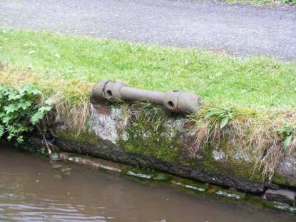
Between bridges 33 and 34 at 53°20'28.7"N, 1°59'03.4"W there is what looks like a roller mounted in the edge of the tow path and I don’t have a clue what its for, but I am sure someone knows.
 It looks as if it should be used with Tommy Bars to turn it.
UPDATE
I have been told by Chris and John that these are also used on the Huddersfield Canal to withdraw the drain plug from the bottom of the canal.

The Giant Hogweed must be a reoccurring problem along here on the winding hole between bridges 28 and 29 as there are permanent warning signs. I understand it is a very unpleasant plant to come into contact with.

CRT contractors are doing a lot of work in the area of bridge 24 Woodend Bridge piling the tow path. We were held up for a short time but  they were able to move their pile-driver barge over slightly so we were able to get down the outside of it. This is not a job I would want in the winter months.


The bridge its self has been chopped off at its roots and been removed, it looks as if it will be replaced in the first two weeks of
 June when the canal will be closed Monday to Friday, 8-11 in the morning and 1-5.30 in the afternoon. The notice we saw suggest you try to transit early morning or evening.  This ties in very well for all the boats heading for the Gardener Rally in Bugsworth Basin.

We continued our slow journey to Marple Junction where we turned left back on to the Macclesfield canal mooring just through bridge 2 for the night.

Today’s Journey
26 7¾miles 2 swing bridges, 1 Lift Bridge 1 Junction and 2 canals in 4 hours.

Wednesday, 27 May 2015

Bugsworth Basin Wednesday 27 May 3015

This morning we were strimmed, its the first time its ever happened to us, the grass cutting gang worked their way down the moorings, yes there was grass along the blacking but a wet broom soon got rid of it and what is the alternative, don’t cut the grass at the visitor moorings?
Leaving at our normal time we seemed to meet loads of boats coming towards us. The weather wasn’t too bad but could have been a tad warmer.

We passed a chap repainting the black on the side of his hull, he had moored on a weir which was about 2” above the water and was standing down inside the weir so that his gunwale was just about at chest height.
On this section of canal they have not used fence posts at the back of the tow path but fence stones, can you imagine the work involved, shaping each stone, cutting two holes through for the rails, transporting them all down the tow path and then setting them in the ground every 6 feet, but of course they only had to do it once. Why some have been whitened I don’t know.
I just happened to notice that a bend on the canal put us straight in line with the electricity pylons.


At Higher Poynton the canal broadens out into another wide flash, but like so many, stray to far over and you will be high and dry as the water is very shallow, in this case there are a row of posts to remind you where you should be.

Its strange up we were now in entering the land of quite large marinas, we had not seen any at all for some time and now we have Lyme View Marina, Braidbar Boats, New Mills Marina and Furness Vale Marina all within a few miles of each other.
After passing another fine mill at Marple, The GOYT Mill we stopped for water just before the junction with the Peak Forest Canal,
I must say this is not the fastest tap on the system and as it is right at one end of the moorings we had to use both our hoses to reach it. A cup of tea and a few odds and ends later we were full and set off the 50 yards or so to the junction where we turned sharp right  on The Peak Forest canal,I will never complain about the state of the Oxford canal again, we virtually stopped at every bridge hole as the boat formed a well fitting plug and selecting reverse dragged all the rubbish off the bottom. We had, of should have had two lift bridges and two swing bridges to contend with, but Woodend Lift bridge has been removed, I am not sure if this is permanent or for overhaul. One good thing about these bridges is that there is a mooring bollard on the offside which is very useful for single handed boaters as most bridges you have to cross from the tow path to the off side to operate.

Not long after this it started raining, very light at first but then good heavy steady rain, probably for the final hour. Our destination for tonight was Bugsworth Basin and we were hoping there would be room for us as it can be a popular spot, probably more so at the weekend, but tonight there are probably 18 of us moored here at the moment. The basin consists of several arms and bends so you keep finding boats and spaces as you walk around.  After the rain finally stopped we went for a quick walk round and there is a very nice 3D model of the basin and old lime kilns showing how it use to be.

Today’s Journey


14 miles, I lift bridge, 2 swing bridges 2 junctions in 7 hours